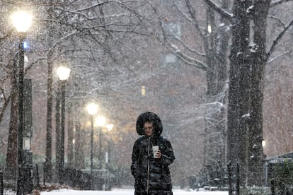
A massive winter storm is set to sweep across the United States from coast to coast, starting on Friday. The system, described by meteorologists as potentially historic, will stretch over 2,000 miles and affect more than 30 states, from the Southwest to the East Coast. At its peak, more than half of the country’s population is expected to experience snow, sleet, or freezing rain at the same time.
The phenomenon will combine heavy snowfall, significant ice accumulation, and a mass of Arctic air that will bring extreme…
A massive winter storm is set to sweep across the United States from coast to coast, starting on Friday. The system, described by meteorologists as potentially historic, will stretch over 2,000 miles and affect more than 30 states, from the Southwest to the East Coast. At its peak, more than half of the country’s population is expected to experience snow, sleet, or freezing rain at the same time.
The phenomenon will combine heavy snowfall, significant ice accumulation, and a mass of Arctic air that will bring extreme temperatures for several days. The result, experts warn, could bring transportation to a standstill, cause prolonged power outages, and other serious risks, especially in regions unaccustomed to this type of weather.
Trajectory and impact
The storm will begin to develop on Friday in the Southwest and Southern Plains before moving toward the Mississippi Valley, Southeast, and Mid-Atlantic over the weekend. Cities such as Dallas, Oklahoma City, Little Rock, Nashville, Atlanta, Charlotte, Washington, D.C., Philadelphia, New York, and Boston are within the impact zone. In many of these places, the system will be accompanied by temperatures so low that snow and ice will not melt for days.
One of the biggest areas of concern is the south of the country, where the combination of freezing rain and frigid air could cause severe ice storms. In states like Texas, Arkansas, Louisiana, Georgia, North Carolina, and South Carolina, forecasts predict accumulations of up to half a centimeter of ice — enough to bring down trees, collapse power lines, and make roads and streets impassable. In these areas, authorities fear prolonged power outages and a limited response from emergency services.
In Texas, Governor Greg Abbott has declared a state of emergency ahead of the storm’s arrival. The measure activated state resources, including the National Guard and Department of Transportation crews, to respond to dangerous travel conditions and potential infrastructure failures. In the northern part of the state, including the Dallas–Fort Worth area, a Winter Storm Watch has been issued starting Friday. Forecasters warn of a “weather whiplash” phenomenon, with temperatures dropping rapidly, increasing the risk of broken pipes and damage to homes.
Further north, snowfall will be heavier. From New Mexico and northern Texas, through Kansas, Oklahoma, and the Ohio Valley, to the mid-Atlantic and New England, heavy snowfall is expected with accumulations of 6 to 12 inches (15 to 30 centimeters), with even higher totals in parts of the Appalachians. In some mountainous areas, more than 23.6 inches (60 centimeters) of snow could accumulate. In the northeast, cities such as Philadelphia, New York, and Boston could face the heaviest snowfall of the season, with conditions exacerbated by sub-zero temperatures.
The cold will remain a major factor even after the main system moves out into the Atlantic. A polar vortex outbreak will push extremely cold air from Canada, leaving about 100 million people in sub-zero temperatures through early next week. In some regions of the Midwest and Northeast, thermometers could dip below -20 degrees Fahrenheit (-28.8 degrees Celsius), with the potential to break records dating back to the 19th century. This prolonged cold will not only make outdoor exposure more dangerous, but it will also make snow and ice removal more difficult and increase the risk of hypothermia and frostbite.
Transportation
Forecasters estimate thousands of flight cancellations over the weekend, with key airports affected by persistent ice and snow. On the ground, interstate highways such as I-20, I-30, I-35, I-40, and parts of I-95 could become impassable in various sections, isolating entire communities for days.
Authorities and meteorologists agree that advance preparation will be key: from securing basic supplies and medications to avoiding unnecessary travel and protecting homes and infrastructure.
Sign up for our weekly newsletter to get more English-language news coverage from EL PAÍS USA Edition